The mopram project
MOPRAM is a multidisciplinary project, which couples together expertise of radio propagation, meteorology and hydrology. It is funded by Fondazione Cariplo, a philanthropic organization that devises research programs in different areas.
Rainfall estimates are usually obtained from rain gauges or weather radars. However, both these types of measurements suffer from restrictions and errors. An alternative method relies on measurements of the signal loss induced by rain on microwave links. Experimental results presented in the past ten years confirm the potentiality of the method. However, none of them applied tomographic techniques to retrieve the 2D rainfall field from measured data. Tomography awards an high accuracy, but so far it has never been applied over real data, until very recently on a limited set of radio links, by one of the project partners.
We believe that the capacity in rainfall observation achievable through tomography from microwave links will lead to improvements in the prediction, prevention and mitigation of hydrogeological instability, related in particular to extremes events, and in the knowledge of hydrogeological basins.
The project kicked-off in April 2017 and will last three years. It has been divided into five activities, corresponding to as many workpackages (WP). Figure 1 is a sketch of foreseen MOPRAM activity.
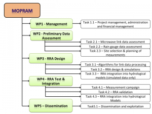 Figure 1 – Scheduled activity MOPRAM
WP1 is instrumental to the success of the project as it takes care of ensuring coordination, integration, and exchange of information among the three project partners.
WP2 consist in investigating the preliminary data available with three different aims. First, carry out data quality control, cross-validation of rain gauge datasets and their comparison with disdrometer data, highlighting the issues related to the usage of each dataset. A preliminary set of microwave link data will be processed to elaborate statistical signal models in view of the design stage. Here we will investigate the relation between microwave link attenuation and rain intensity considering different kinds of events (convective and stratiform rain and possibly solid precipitation) and testing different models for raindrop size distribution. Finally, the field trials will be planned: suitable areas will be identified and measurement requirements will be defined.
In WP3, we will design, implement and test the Rain field Reconstruction Algorithm (RRA) within a controlled scenario, i.e. using synthetic rainfall fields given by an historical set of radar maps collected from the Spino d’Adda weather radar. The algorithm is based on a tomographic inversion technique. We will perform a statistical analysis in order to test the agreement between the reconstructed rainfall fields and the radar rainfall fields (assumed as truth) investigating such issues as extremes (maximum and minimum values), space-time intermittency (i.e., wet and dry areas) of the rain fields and scale invariance. Finally, the synthetic maps obtained by the RRA will be assimilated into hydrological models and the outputs will be checked against the ones obtained from the radar maps.
In WP4, we will apply the RRA to observed rainfall fields using the data collected during measurement campaigns. The ground truth will be provided by selected rain gauge datasets and the use of disdrometers. Then, the RRA-based maps of rainfall will feed different hydrological models (namely, GUH, HBV, TOPKAPI) with different level of complexity and description of the hydrological response, and the corresponding outputs will be compared with the ones obtained from classical inputs.
WP5 will include all the activities necessary to circulate MOPRAM outcomes among the scientific community and other target groups (i.e. Public bodies, companies and citizens).